NDVI Crop Health Maps
From Your Standard Drone.
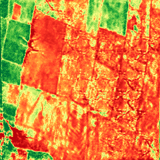
Nabhya reconstructs near-NDVI crop health maps from standard RGB drone footage — no multispectral sensor, no hardware changes.
A multispectral camera costs ₹8–12 lakh. Most Indian drone operators — 1,400+ DGCA-certified — fly standard RGB sensors and generate zero crop health data per flight.
Who Uses Nabhya
Turn every RGB flight into a crop health flight.
- No hardware changes — works with your existing fleet
- One REST API call returns NDVI map in < 2 seconds
- Add crop health to your service offering, no sensor cost
- Batch processing for full-flight image sets
Actual model output — unedited.
How It Works
pixel-level inference
Accuracy Check
Every output cross-checked against held-out Sentinel-2 ground truth. SSIM 0.8060 across 440 validation images.
Built on Real Science.
Developed to make satellite-level crop analytics affordable to all growers in developing ecosystems — bypassing multi-lakh camera hardware.
Verified model accuracy
SSIM 0.8060 on 440 held-out Sentinel-2 images — a reproducible, auditable methodology. 16.8% above the published benchmark.
Fast at scale
Under 2 seconds per image. Designed for batch processing — submit a full flight's worth of frames in one API call.
India-focused
Built for the Indian agri-drone ecosystem. Trained on Indian field imagery.
Audit-ready output
Every score tied to ground-truth imagery. Exportable JSON/PNG — designed for PMFBY-claims documentation.
Honest about stage
MVP — field trials in progress. Early partners get direct access to the founding team.
Nationally Recognized
Verify ↗1st Prize, AgriTech Yuva Competition 2026 — selected among 11 national finalist teams.
Common Questions
Pilots run on your existing flight imagery — no hardware changes, no fleet disruption. One REST API call returns JSON + PNG output.
Who Built This
Galgotias University, Greater Noida · AgriTech Yuva 2026, 1st Prize · IEEE Hackathon Winner 2026
Drop an image here — get its NDVI map
No signup required · under 2 seconds · actual model output
Open Live Demo →Partnership & Demos
Interested in partnerships, pilots, or demos? Let's talk about your farm network and monitoring needs.